 |
From Mid-Hudson region
(West of Hudson)
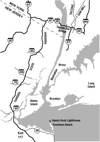
Thruway (Interstate 87) south. Watch out for large sign "287 to New Jersey", DO NOT go that way, instead bear towards Tappan Zee Bridge. Exit onto Garden State Parkway south. (Continue below)
From Mid-Hudson region
(East of Hudson)
Taconic Parkway south, exit onto Saw Mill Parkway south, then watch for signs for Tappan Zee Bridge. After bridge, exit onto Garden State Parkway south. (Continue below)
Garden State Parkway
Continue south on Garden State Parkway. (When Parkway divides, use either the Express or Local lanes, whichever is better for traffic conditions.) Take Exit 117 onto State Rt. 36 south (follow sign for Gateway National Recreation Area). Continue on Rt. 36 about 12 miles. Nearing the shore, watch for sign "Sandy Hook / Gateway National Recreation Area next right" just before a drawbridge. Immediately following the drawbridge, an exit ramp to the right crosses back over Rt. 36 into the park.[ Map of park layout ]
From Points South and Other Areas
Click for an interactive map of: Gunnison Beach and Fort Hancock area
![[MapBlast: Gunnison Beach]](http://www.mapblast.com/myblast/images/corporate/rect_logo.gif)
|